

Nicole Kieninger
Wir hatten als Familie eine 2-stündige Quadtour, gebucht und wurden sehr positiv überrascht. Die Söhne sind 16 und 19 und daher selbst gefahren. Wir hatten als Familie zwei Guides und waren für uns, es gab also keine große Gruppe, bei der immer auf jemanden gewartet werden musste, sondern nur auf mich ;-) und hier hatten sich die Guides dann abgesprochen. Der Spaß war entsprechend groß. Bei der 2-stündigen Tour konnten wir vom höchsten Punkt Koh Samuis die Landschaft bewundern und den großen Buddha. Der Fahrspaß war so groß, dass meine Männer nochmals eine 1-Stündige Tour gebucht haben nur um nochmals fahren zu können und auch hier waren sie allein als Gruppe unterwegs. Man sollte dabei jedoch nicht empfindlich sein, was Dreck angeht, denn der Sand wird ordentlich aufgewirbelt. Da wir schon in vielen Urlauben ähnliche Ausflüge gebucht hatten, können wir sagen, dass diese Quadtouren die bisher Besten waren und kaum zu toppen sind.

Ed Lees
Great half day tour, from booking the night before for a next morning trip everything was well communicated and very promptly. The tour itself was made so much better by our guide and driver who took great care of us for the whole trip. Our guide was knowledgeable, courteous and interacted with us for the majority of the trip. Would recommend 👍🏻

Nicole Haas
Wir haben heute die Tour zum Angthong NationalPark gemacht. Die Tour ist sehr gut organisiert. Sehr nettes zuvorkommendes Personal, gutes Essen. Ich habe meine Schuhe im Bus vergessen. Eine Stunde später konnte ich sie schon an der Rezeption abholen. Einfach klasse. Vielen Dank für diesen tollen Tag.

אופיר סויסה
רוצה להודות ולהמליץ על שליו מסיאם טורס על תכנון טיול מושלם, בהקשבה מדויקת למה שאנחנו צריכים, טסנו עם תינוקת והיה ראש שקט!!!!!!!! כל המעברים היו מושלמים! ללא המתנה בכלל, תמיד בזמן ובדיוק! סבלני קשוב פשוט כיף כיף כיף! אין ספק שאת הטיול הבא הוא יתכנן!

sandie's journeys
I highly recommend picking this company for the tours they do. We went looking for pink dolphins, which we saw, snorkeling and then pig island. Lunch was included. It was a fantastic day
Hidden inside the limestone cliffs of Koh Mae Ko, the Emerald Lagoon is one of the most recognisable sights in Ang Thong Marine Park. In Thai it is called Talay Nai, meaning “inner sea”, which describes it more accurately than its English nickname.
The lagoon is a body of seawater almost completely enclosed by rock. From the boat, you cannot see that it is there. Visitors follow a stepped path up the side of the island before the water appears below, surrounded on every side by steep limestone and thick vegetation.
It is a short visit on most Ang Thong tours, but there is far more to the lagoon than a good photograph. Talay Nai is also one of Thailand’s notable geological sites.
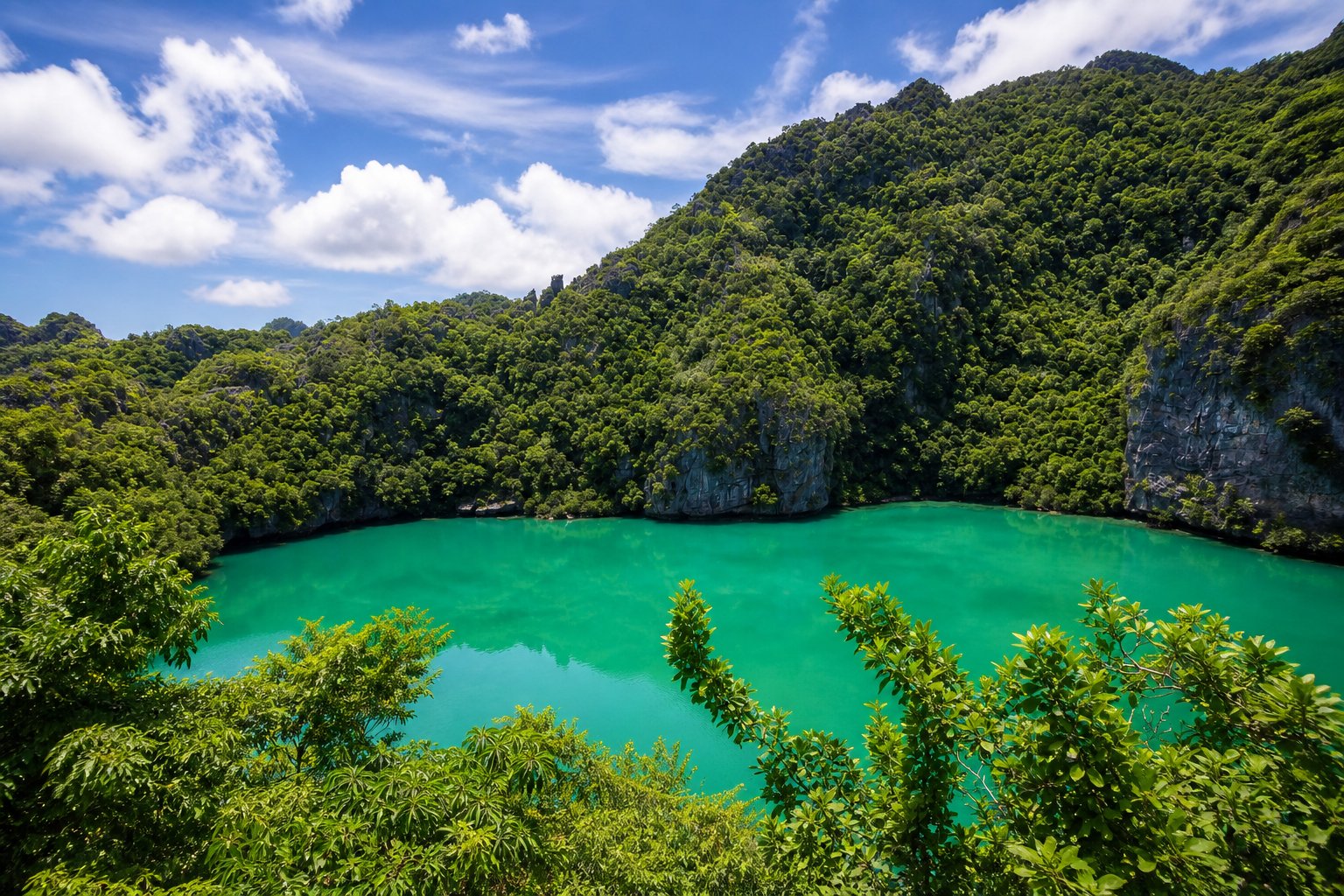
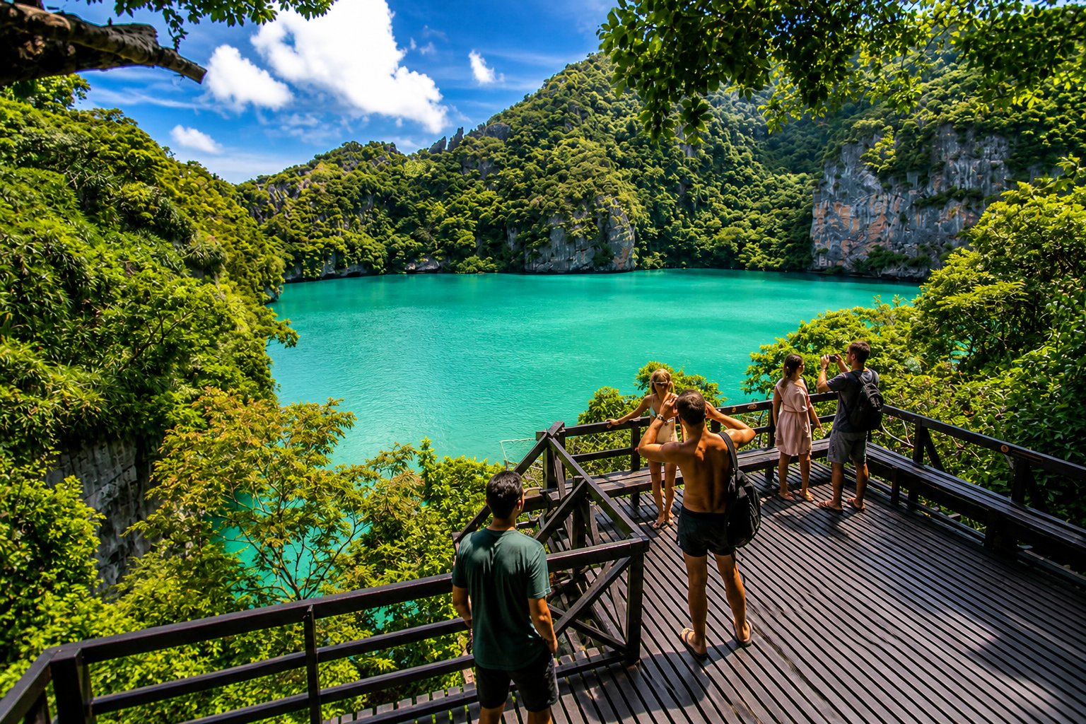
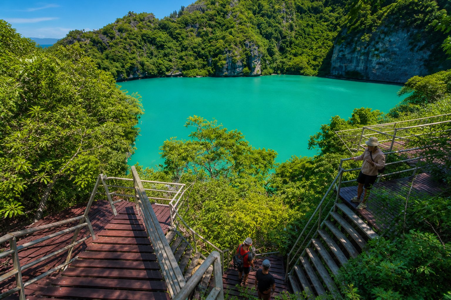
Talay Nai is roughly circular and measures about 250 metres across. It lies inside Koh Mae Ko, approximately one kilometre north of Koh Wua Talap, the island where the national park headquarters is located.
Although the lagoon looks completely landlocked from above, it is not a freshwater lake. Cavities and channels in the limestone connect it to the Gulf of Thailand, allowing seawater to pass through the rock.
This explains why the lagoon is sometimes described as a marine lake. It is part of the sea, but its surface is sheltered from the waves by a natural ring of cliffs.
Koh Mae Ko is one of 42 islands within Mu Ko Ang Thong National Park. The whole protected area covers approximately 102 square kilometres of islands and sea in Surat Thani Province.
A surprisingly common story claims that Emerald Lagoon formed inside an extinct volcano. Thailand’s Department of Mineral Resources says this is incorrect.
Koh Mae Ko is made from limestone, not volcanic rock. The lagoon occupies a large sinkhole created by the gradual dissolving and collapse of limestone.
The story began around 260 million years ago, during the Middle Permian period. Material rich in calcium carbonate, including the remains of marine organisms, accumulated in a shallow sea. Over a very long period, these deposits were compressed and turned into limestone.
Movements in the Earth’s crust later lifted the limestone. Rainwater, surface water and groundwater then worked their way into cracks in the rock. Water becomes slightly acidic as it absorbs carbon dioxide, which allows it to dissolve limestone very slowly.
This process produced the rugged karst landscape seen throughout Ang Thong today. Karst landscapes commonly contain caves, fissures, underground waterways and sinkholes. At Talay Nai, underground cavities grew until part of the rock above them collapsed, leaving a deep, rounded depression.
Later changes in sea level and the landscape allowed seawater to enter through openings below the surrounding cliffs. The result is the inner sea visible today.
The cliffs around Talay Nai are more interesting when you know what you are looking at. The limestone varies from grey to dark grey and occurs in both thick and thinner layers. Thailand’s geological survey has also recorded bands and small pockets of chert within the limestone.
Chert is a hard, silica-rich rock that can weather differently from the softer limestone around it. Faulting is also visible in the rock on Koh Mae Ko, including near an outcrop beside the beach and the route towards the lagoon stairs.
These features are small clues to a history that took place over hundreds of millions of years. The cliffs were once sediment on the floor of an ancient sea, long before the modern Gulf of Thailand existed in its present form.
Stairs and raised walkways lead from the landing area towards several viewing platforms. The climb is much shorter than the hike to the main viewpoint on Koh Wua Talap, but it can still feel demanding in the midday heat.
Some sections are steep, and the steps may be damp after rain or spray. Shoes or sandals with a secure back are a better choice than loose flip-flops. Keep one hand free for the railing and carry water, even if your tour is only ashore for a short time.
The first elevated platform gives you a partial look at the lagoon. Higher platforms reveal more of its shape and show how completely the cliffs surround the water. If your fitness and the conditions allow, it is worth continuing beyond the first view.
People with knee problems, limited balance, a strong fear of heights or difficulty climbing steep stairs should assess the route carefully. You can normally remain near the lower landing area if the climb is unsuitable, but ask your guide about the arrangements before leaving the boat.
No. Emerald Lagoon is a protected natural feature to be viewed from the designated walkways and platforms.
Visitors should not try to climb down to the water or leave the marked route. The surrounding limestone is steep, sharp and unstable in places. Staying on the official path also helps protect the vegetation and reduces disturbance inside the lagoon.
Park rules and access conditions can change, so follow the signs and the instructions given by park staff and your guide on the day of your visit.
The name Emerald Lagoon can create the impression that the water always has the same bright green colour. In reality, its appearance changes.
Sun angle, cloud cover, shadows from the cliffs, recent weather and conditions in the water can all affect the colour you see. It may appear vivid green in direct light, darker green under cloud, or blue-green at other times.
The higher platforms usually give the clearest overall view because you can see more open water and less reflection from the surrounding rock. Bright conditions often produce stronger colour, but softer light can reveal more detail in the cliffs and vegetation.
The viewpoints are compact and can become busy when several boats arrive close together. Take your photographs, then move aside so other visitors can reach the railing.
A wrist strap or neck strap is useful because you will need your hands on the steeper sections. Avoid walking while looking through your phone screen. Stop somewhere safe before taking a picture.
A normal phone camera is wide enough for most views. From the upper platforms, try including part of the surrounding cliff in the frame. This gives the photograph a sense of scale and shows why Talay Nai is called an inner sea.
The lagoon does not need heavy colour editing to look impressive. Its appeal comes from the contrast between calm water, pale limestone and dense green vegetation.
Many day tours follow similar schedules, so Koh Mae Ko can receive several groups within the same part of the day. The platforms may be busy for a short period and then noticeably quieter once a group returns to its boat.
A less crowded visit depends more on a tour’s route and arrival time than on the size of the park. If Emerald Lagoon is important to you, check that Koh Mae Ko appears in the current itinerary and ask when the boat usually visits.
Itineraries can change because of sea conditions, weather, park instructions or safety considerations. No responsible operator should guarantee access regardless of conditions.
Talay Nai is a protected geological feature, not a swimming stop or adventure playground. Stay on the marked route, take all rubbish back to the boat and avoid touching or removing rock, plants or wildlife.
The most useful thing visitors can do is also the simplest: leave the island as they found it. This keeps the route safe and helps preserve the lagoon for the people arriving after you.
Visitor information checked August 2026. Access and park rules can change, so follow current instructions from park staff and your tour guide.
Talay Nai translates as “inner sea”. The name refers to the seawater enclosed inside the limestone cliffs of Koh Mae Ko.
No. Thailand’s Department of Mineral Resources identifies it as a limestone sinkhole. It formed through the dissolving of limestone and the eventual collapse of underground cavities.
The limestone on Koh Mae Ko dates to the Middle Permian period and is approximately 260 million years old.
No. Openings and cavities in the limestone allow water to move between the lagoon and the surrounding Gulf of Thailand.
No. Visitors view the lagoon from the official stairs and platforms. Do not leave the marked path or attempt to descend to the water.
It is shorter than the Koh Wua Talap viewpoint climb, but there are steep stairs and the heat can make it tiring. Secure footwear and a free hand for the railing are recommended.
No. The apparent colour changes with sunlight, cloud, shadows, weather and water conditions.
Many do, but not every itinerary is identical. Check that Koh Mae Ko or Emerald Lagoon is specifically included before booking.